Understanding the Wilaya AlForat: Heart of Daesh’s Homeland
Waleed al-Rawi and Sterling Jensen
Daesh[i]’s Wilaya AlForat, or the Euphrates State, along the Iraqi-Syrian border is the heart of the terrorist organization’s homeland, yet it is not understood and is easy to bypass due to its both simple and complex tribal and geologic nature. While the perceived sectarian policies of the Iraqi government and the brutality of the Assad regime provide the oxygen and nutrients to sustain Daesh and marketing savvy and disenfranchised youth enable its reach and growth, the tribal lands in the vast desert landscape to the north and south of the Euphrates between Syria's Aleppo and Iraq's Fallujah provide Daesh the vital structure and muscle tissue it needs to function.
The borderline between modern day Western Iraq and Eastern Syria has roots in the infamous Sykes-Picot Agreement of 1916. Regardless of how understanding of the Sykes-Picot Agreement has taken on mythical proportions in the Arab world as well as among many Western Arabists, it remains a powerful symbol of the West’s hand in determining the fate of the Middle East. One of Daesh’s declared objectives is to make this borderline obsolete, thus beginning the end of Western and colonial vestiges in the Islamic world. Maintaining a safe haven in Daesh’s Euphrates State is essential to this objective.
Challenges in governing this region are not new. Both the Ottomans and the British struggled to control the area from Deir al Zor to Haditha before the rise of the Baath party. In 1995 the Baathist regime in Iraq seriously considered dividing Anbar into two provinces calling western Anbar the Higher Euphrates Region or the Jazeera Province. It sought to do this to because as Iraq's largest province Anbar was too difficult to govern and tribal leaders in the Western region lobbied Saddam Hussein to give them more provincial autonomy, thus freeing them from having to compete with Ramadi and Fallujah for provincial resources.[ii]
This area is difficult to govern because it is inhabited by different tribes that straddle the Iraqi-Syrian border that are not oriented toward either Damascus or Baghdad. In addition, the Iraqi border with Jordan and Saudi Arabia is largely barren with Bedouin nomads without villages or towns. That makes these borders very porous and nearly un-controllable. With a homogeneous culture, religion and ethnicity, this no man's land provides radical jihadists fertile ground for safe-haven, recruitment and training, as well as access to Iraq, Syria, Jordan and Saudi Arabia.
This brief monograph details the geographic and demographic make-up if this area and how it has become the heart of Daesh's homeland and ambitions.
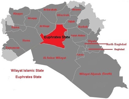
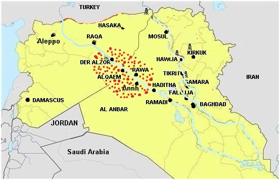
Daesh published a map of its wilayat (states) in Iraq and Syria (Illustration 1) on August 31, 2014. These borders take into consideration tribal, geographic and political boundaries, and differ from the political boundaries resulting from the Sykes-Picot Agreement. The Euphrates State’s eastern most border is between Anah and Rawa and its western most border is between Deir al Zor and Raqqa (Illustration 2).

Illustration 1: Daesh’s Map of Wilayas in Iraq and Syria. Source: وكالة اعماق الإخبارية العاءدة لداعش

Illustration 2: The Area of Euphrates State (in red dots). Source: Waleed al-Rawi
The Main Tribes in This Area:
Albu Mahal
Al-Raween
Al-Anieen
Al-Jasha'am
Albu Hardan
Al-Suleiman
Al-Karabula
Al-Mishahid
Albu Sha'aban
Al-Mirasima
Al-Kbasat
The Euphrates State is largely homogeneous with Sunni Arab tribes that have the similar dialect, culture and religious preferences. While the towns along the Euphrates such as Deir al Zor, Anah, and Rawa have deep and rich history, the social and political ties of these areas have largely remained local and not well integrated in the power structures of Syria or Iraq. The tribal make-up and cultural preferences of the people from this area has not changed significantly since 1916 (See Table 1). Radical jihadists understand this fact and have exploited opportunities the area offers to establish safe havens. The network of transporting radical jihadists between Eastern Syria and Western Iraq that was originally built by Syrian intelligence officers in the run up to the US invasion of Iraq in 2003 and then later adopted and adapted by Jordanian terrorist Abu Musab al-Zarqawi has become a vital area for Daesh’s recruitment, training and movement between Iraq and Syria. However, before discussing how Daesh uses the area, we will discuss the geography of the area and how it is administered.
Geography
The western region of Anbar is divided into two main areas, the Jazeera (Arabic for island) north of the Euphrates River up to the Tigris, which is part of the Ninewa Province. The second region is to the south of the river, or the Shammia, or Levantine, area that is part of the Syrian desert. We will describe the Al-Qaim District, as it is the center of the Euphrates State.
Al-Qaim District
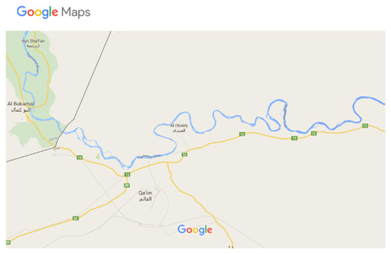
Al-Qaim District is split into two parts, Al-Rummanah which is located in the Jazeera and Al-Obeidi area in the Shammia. Al-Obeidi is located on the main road that goes west to Husaiyba, which is the center of Al-Qaim. Al-Obeidi has many government housing complexes for the employees at the phosphate plant and cement factory, as well as a residential area. Both the phosphate plant and cement factory employ many of the local residents. The Albu Mahal tribe mainly reside in the Obeidi area along with al-Raween.

Illustration 3: Map of the Syrian-Iraqi border near al-Qaim. Source: Google Maps
To the west of Obeidi is a village named Afeita where the Jasha'am live and to the west of Afeita is the village Saada where the Albu Mahal, Albu Hardan, and al-Suleiman live. To the west of Saada is the village of Karabala where the al-Karabala and al-Raween tribes live. Then there is the city of Husaiyba which is the center of Al-Qaim district where different tribes live.
At the river crossing in Husaiyba to the Jazeera, the inhabited area is the Al-Rumannah neighborhood which is 30 km from the Iraqi-Syrian border. The majority of the residents in this area are from the Albu Hardan tribe and on the northern side is the Ratub area which is on the Iraqi-Syrian border where the Al-Obeid and some Albu Faraj live. North of Ratub is al-Baguz, which is split by the border, where the Al-Jasha'am live. This road continues up into the Ninewa Province.
Going east of Al-Ramannah, the first village is al-Darijah where the al-Raween live. East of al-Darijah is 'Ash where the Al-Jasha'am live and then there is a desert road that arrives to Rawa.
Al-Qaim and al-Qaeda
The area of Al-Qaim has great importance to militant groups that formed after the US occupation of Iraq in 2003, especially Jordanian terrorist Abu Musab al-Zarqawi’s tawheed wal-jihad which became al-Qaeda in Iraq in October 2004. This area is important for a number of reasons. It was the primary entry point for Arab volunteers coming from Syria to help the Saddam Hussein regime before the war. In fact, around 8000 volunteer fighters crossed the Albu Kamal (Syria) - Al-Qaim (Iraq) entry point before the war, majority of who were Syrians.[iii] The Euphrates River is a secure area for transportation and it's difficult to conduct thorough reconnaissance of this area. Additionally, there is deep social and tribal integration with many inter-family marriages and hared religious views. Tribes in this area are overwhelmingly Sunni Muslims and have recently adopted the Hanbali school of thought (Wahabis in Saudi Arabia come from the Hanbali school of Sunni jurisprudence). Also, the area was the exit route after the US invasion, so fighters are familiar with the places to get food and other logistics to easily return to Syria. Lastly, a large number of small villages along the Euphrates in this area mean it's easy to get fighters in and out Iraq from Syria.
Guest Houses
Zarqawi’s tawheed wal-jihad (TWJ), Al-Qaeda in Iraq and then the Islamic State of Iraq established rest and receiving houses and called them al-mudhafat or guest houses, which is a combination of dhaif and dhayafa (Arabic for guest and hospitality respectively). The guest houses were valuable because they were near a transportation hub, were relatively safe, provided places to sleep, eat and get medical care, had briefing rooms for fighters to learn about their missions and were waiting stations before fighters left on their assigned missions.
Since western transportation hubs were the primary hubs for help and supplies to al-Qaeda, many guesthouses were established in this transportation hub, including the Al-Hussaiba, Al-Muadhid, Anah 1 and Anah 2, Rawa, and Karabla guesthouses.
Training Camps
Rawa Training Camp
Rawa's training camp was the first established for foreign fighters joining TWJ under the leadership of Zarqawi. The camp started in June 2003 in the Wadi Emir area that is 10 km west of Rawa where it took advantage of the valley's terrain and caves. A Saudi veteran from Afghanistan who was trained at the Farooq Camp in Peshawar, Abu Raghed al-Otaibi, was appointed head of the camp. Al-Otaibi had entered Iraq from Syria and prepared the Rawa camp before Zarqawi arrived in Iraq. There were well know figures from al-Qaeda teaching at the Rawa camp, including Omar Hadid and Abu Mohamed Lubnani and Abu Anas al-Shami and Abu Ibrahim al-Tunisi and Abu Tareq al-Yemini and Abu Hamam al-Urdoni.
All foreign fighters were sent to the Rawa camp for training. It was an important camp because of its location on the transportation hub between Iraq and Syria and was an important infusion center where foreign fighter skills mixed with the skills of Iraqi fighters. US fighter jets struck the Rawa camp on August 8, 2003, killing the emir of the camp with 80 fighters.
Wadi Horan Camp
Wadi Horan is one of the most important military locations in the area as the valley is 360 km long, starting from Saudi Arabia's Arar in the Western Desert, then ending at the Euphrates River near the town of Haditha. The valley is 50 to 100 meters deep and in some places is cut by a series of tall hills and plateaus. Dry streams in Wadi Horan are dangerous during seasonal rains, threatening the rock-formed dams and blocking off roads, especially the roads west to Anah and Al-Qaim. In the 1980s many dirt dams were built to prevent this, causing man-made lakes with natural vegetation and wild animals.
During the Kuwait War in 1991, British and Australian troops looked for platforms for land-to-land missiles in Western Anbar and Wadi Horan seemed to be the best place for this. The Islamic State of Iraq took Wadi Horan as one of its principle places for building guest houses and training camps, as well as logistics and support bases. The valley has strategic importance for Jordan and Syria, as it connects the Western Desert with the provinces of Samawa and Najaf, securing cover and hiding. Wadi Horan is a vital area for the Anbar Wilaya (see Illustration 1) as it allows al-Qaeda fighters movement to all areas in Anbar.
The Euphrates State and Daesh
Largely due to marginalizing policies of the government of former Iraqi Prime Minister Nori al-Maliki's which targeted Sunnis, Daesh was able to re-establish a popular safe haven in Western Anbar after being significantly weakened from Sunni grassroots sahwa or Awakening groups and a surge of US troops in Iraq (2006-2009). Daesh's re-concentration in Western Anbar led to a deepening of ties with local tribes and pledges of loyalty to the Daesh, especially after the conflict in Syria opened the borders between Iraq and Syria.
On August 31, 2014 Daesh announced the establishment of the Euphrates State to include the Western Anbar areas with Haditha on its eastern border and Deir al Zor on its western border, bordering the former Deir al Zor Wilaya now named "Wilaya al-Kheer." (See Illustration 1)
The new Euphrates State includes Anah, Rawa, al-Obeidi, al-Karablah, al-Qaim, al-Ramada on the Iraqi side and on the Syrian side Abu Kamal and Der al Zor with its villages (See Illustration 2). Daesh established the Euphrates State because it views the Syrian-Iraqi border as the result of colonial policies (Sykes-Picot). It also does not think Baghdad will be able to control Western Anbar as Anbar is a large province making up one third of Iraq's geography. Daesh also understands how to navigate the social and tribal inter-connectedness in these areas more than either then Syrian or Iraqi governments.
Conclusion
The Euphrates State is of strategic importance to Daesh as it is the geographic and demographic center of gravity of its regional safe haven. The local customs, tribal make up and geography of the area allow Daesh to recruit local leaders, transport fighters between Iraq, Jordan, Saudi Arabia and Syria and provide the needed support and logistics for training and operations.
In light of the gains against Daesh the Iraqi Army has made in Anbar with the significant airpower assistance from the US-led coalition, Daesh has retreated west of Ramadi into Hit, Rawa, Anah and al-Qaim. The coalition airstrikes have coerced Daesh to change its military forward strategy. It will no longer try to hold larger urban areas such as Ramadi, but will maintain its safe haven in the Eurphrates State and adopt more guerilla tactics of attack and retreat and engage in a war of attrition with the Iraqi forces which will continue to rely heavily on a centralized Baghdad for support. While Iraqi forces backed by Shiite militias will be able to make temporary gains against Daesh as long as Coalition airstrike continue, Daesh assumes its adoption of guerrilla tactics will wear down the resolve of the Iraqi army and US-led Coalition to continue the current pressure on them. Daesh assumes the Iraqi army will not make gains against its units or maintain control of former territories without coalition airstrikes.
Moreover if the Iraqi government repeats its strategy of Shiite-militia infiltration into security forces in Anbar as it has done in Salahideen and Diyala, Daesh is sure to exploit this weakness in the Iraqi government strategy. Guerrilla tactics in Sunni areas with the presence of Shiite-led forces have proved a successful tactic for Daesh to weaken local trust of security forces. Daesh will seek to render law enforcement ineffective and insufficient, thus making it more difficult for the Anbar government to govern the province and provide needed services for reconstruction.
One factor enabling Daesh's safe haven in the Euphrates State is a lack of anti-Daesh coordination between the US, Russia, Syria, the Syrian opposition and Iraq. Since Russia and the Syrian Army led by Bashar al-Assad cannot strike Daesh within Iraqi territory and the US-led Coalition against Daesh is limited in its striking capabilities in areas overlapping Russian and Syrian strikes in Syria, Daesh will be able to use this no-man's zone in the Euphrates State to its advantage.
The Euphrates State will remain the heart of Daesh's strategy in Iraq and Syria. It is essential for its operations, logistics, recruitment and training. Without a safe haven from Deir al Zor to Haditha, Daesh would be unable to mount significant attacks in both Iraq and Syria.
The views in this article are solely those of the authors.
End Notes
[i] We will refer to the self proclaimed Islamic State (IS, ISIS, or ISIL) with the Arabic language acronym Daesh. Wilaya is the Arabic word for a state (not an independent country), whereas dawla is the Arabic word for an independent state (as in al-dawla al-islamiya, or the Islamic State).
[ii] Waleed al-Rawi interview with Sheikh Sabah Sattam, leader of Albu Mahal tribe in al-Qaim, Amman, Jordan, Aug. 19, 2015
[iii] Dr. Waleed al-Rawi worked with the files of Arab fighters entering Iraq from Syria while a brigadier general at the Iraqi Ministry of Defense before the US invasion in 2003.
